PropTech
Tamil Nadu LandGrid
Survey numbers and land boundaries on satellite maps for Tamil Nadu
Find Tamil Nadu survey numbers and subdivisions on satellite maps with village, taluk, district and extent in acres and cents.
About the work
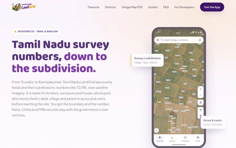
Tamil Nadu LandGrid: the homepage
Tamil Nadu LandGrid is a mapping tool that displays survey fields and their subdivisions across all 38 districts of Tamil Nadu on satellite imagery. It is designed for brokers, surveyors and house-site buyers who need a field's taluk, village and extent in acres and cents before visiting a site.
The app allows users to zoom into villages to see full survey numbers on high-resolution satellite imagery, search by village or taluk name, and use GPS to centre the map on their location. Each field displays its survey and subdivision number with village, taluk and district information, plus an extent calculated from the mapped boundary in acres, cents and square feet.
Users can measure areas by touching corners for site dimensions and perimeter, or draw lines to check road frontage. The app also offers printable PDF village maps showing every survey number in a village with their outlines at A3 resolution.
All core features—browsing the map, reading survey numbers and boundaries, measuring and calculating extent—are free. Village survey map PDFs are the only paid purchase.
On display
- High-resolution satellite imagery with field boundaries
- Village and taluk name search with GPS location
- Extent calculation in acres, cents and square feet
- Area and perimeter measurement tools
- Saved measurement history
- Village survey map PDF download
- Shareable field links
- Tamil and English language support
Pricing
Pricing model: Freemium
Compare and explore
See the alternatives to Tamil Nadu LandGrid, more in PropTech.
Follow Tamil Nadu LandGrid and hear about their milestones, new launches and demo videos by email. Stop any time.
Tamil Nadu LandGrid: wall label
- Medium
- PropTech
- Provenance
- India
Tamil Nadu LandGrid: metrics
Appraisal of tnlandgrid.com: Ahrefs Domain Rating and Majestic link provenance, with the change since the last viewing.
- Domain Rating
- 7
- no change since last check
- Trust Flow
- 0
- no change since last check
- Citation Flow
- 7
- no change since last check
- Referring domains
- 2
- no change since last check
- External backlinks
- 55
- no change since last check
Ahrefs Domain Rating appraised 21 Nov 2026, re-hung 21 Nov 2026. Majestic appraised 21 Nov 2026, re-hung 21 Nov 2026. Link provenance: Majestic. Trust Flow, Citation Flow and Topical Trust Flow are trademarks of Majestic-12 Ltd.
Tamil Nadu LandGrid: domain provenance
Trace the provenance
Checked 21 Nov 2026, 20:50 UTC from the public RDAP record.
- Domain age
- 6 days
- Registered
- Expires
- Registrar
- Cloudflare, Inc.
- DNSSEC
- Not signed
Tamil Nadu LandGrid: launch provenance
What we have measured for Tamil Nadu LandGrid since it went live on Novara Launch on 21 November 2026.
- Domain Rating (Ahrefs)
- 7
- First measured 21 Nov 2026
- Trust Flow (Majestic)
- 0
- First measured 21 Nov 2026
- Referring domains (Majestic)
- 2
- First measured 21 Nov 2026
Day 0 since launch. Next receipt: day 30, 21 Dec 2026. The figures report a change; they do not say what caused it, and many things can. No figure here is a guess.
Before you launch
See the playbook for a plain launch checklist and the launch directories worth adding your product to.
Visitors ask
- Is there a charge for Tamil Nadu LandGrid?
- Browsing the map, reading survey and subdivision numbers, boundaries and extent, and measuring are all free. A village survey map PDF is the only purchase, paid once per village.
- Does it cover every district?
- Yes, all 38 districts of Tamil Nadu are covered, arranged as district, then taluk, then village.
- Does the app show Patta, Chitta or the FMB sketch?
- No. Tamil Nadu LandGrid is an independent app not affiliated with the Government of Tamil Nadu and does not show Patta, Chitta, the A-Register or FMB sketch contents. It maps survey boundaries from TNGIS data for reference; for official records use the Tamil Nadu e-Services portal or your Taluk office.
- What does a survey number like 56/4 mean?
- 56 is the survey number and 4 is its subdivision. When a survey field is divided after a sale or family partition, each part receives its own subdivision number and is then called 56/4 in Patta, Chitta and FMB records. Later splits add letters and digits, as in 72/1B1.
- Why acres and cents?
- That is how land is quoted in Tamil Nadu: 1 acre is 100 cents and 1 cent is about 435.6 square feet, while house sites are often priced by the square foot. The Chitta usually records extent in hectares and ares, with 1 hectare being about 2.47 acres.
Leave a review for Tamil Nadu LandGrid
No one has reviewed Tamil Nadu LandGrid for the gallery yet. Be first. Every review is free. None are bought.
Tamil Nadu LandGrid has a free listing. The owner can unlock the full profile with a paid launch for $5:
- Founder story (locked)
- Milestones (locked)
- Demo video (locked)
- Dofollow website link: not on this free listing (its website link is nofollow)